Poole History Online is a free online database of photographs, documents and data relating to the local history of the Borough of Poole. This website is managed by Poole Museum and updated by staff and volunteers. Find out more
about this site.
If you experience any problems, please see the
help page.
Showing results 11 to 20 of 42
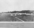
Museum Ref No: F2b_0001Dorset Militia Camp 1877 at Playfields (between Wallisdown and Ashley Road); many white tents and some men on parade in front
Photograph
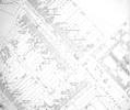
Extract from Ordnance Survey 12.25
Map
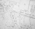
Extract from Ordnance Survey 9.21
Map
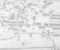
Extract from Ordnance Survey XL1V.9
Map
Extract from Ordnance Survey XL1V.9
Map
Extract from Ordnance Survey XL111.12 1902
Map
Extract from Ordnance Survey XL1V.10
Map
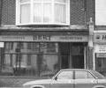
Museum Ref No: C_Parkstone_0087Shop in Ashley Road, Upper Parkstone. 'Bert - Gentleman's Hairdresser', 1987.
Photograph
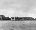
Museum Ref No: AH_Castle_and_Quay_monoPostcard, Brownsea Castle and Quay. Photo by Blake, Montrose Studio, 99 Ashley Road, Parkstone.
From the Andrew Hawkes collection.
Photograph
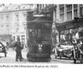
Museum Ref No: AH_TramsPhoto of ex-Poole Tram Car N.57, on Old Christchurch Road, heading to Ashley Road. From the Andrew Hawkes collection.
Photograph